Category: Uncategorized (Page 5 of 15)
Matthew Evans
Margaret Smith
DHSS-HUM-230
6 April 2026
Bulldozing a Path – North Saint Louis and the NGA
This is a documentary that examines the construction of the National Geospatial Intelligence Agency (NGA) campus in North St. Louis and its impact on the local community. This was created by independent filmmakers and researchers, the project combines historical research, archival materials, and oral history interviews to explore how urban development projects can displace residents, erase community history, and reshape neighborhoods.
The primary goal of the project is to document the experiences of residents affected by displacement in North St. Louis. By highlighting both the social and cultural consequences of such projects, the documentary asks critical questions about who truly benefits from development and what is lost when neighborhoods are demolished. It emphasizes the tension between economic goals and the well-being of long-standing communities.
The intended audience includes scholars and students of urban history, race and inequality, and geography, as well as St. Louis residents and members of the general public, urban planning, and community preservation. Through a combination of interviews with residents, archival research, the filmmakers are able to provide a layered perspective that connects the historical sense of communities with the present-day effects of large-scale development.
The project concludes that, while the NGA campus has been promoted as revitalization, it exemplifies a recurring pattern of displacement in North St. Louis. Neighborhoods, particularly those historically populated by Black residents, are cleared, and cultural memory is often lost along with the physical homes. Despite this, the documentary highlights the resilience and resistance of affected communities, showing that even in the face of displacement, local identities persist.
Strengths of the documentary include its use of firsthand accounts and archival materials, which lend authenticity and historical depth, as well as its ability to situate one development project within a larger pattern of urban transformation. Weaknesses include limited discussion of potential economic benefits and a relatively short format that constrains the depth of its history.
Overall, Bulldozing a Path enhances understanding of North St. Louis by adding historical context to display urban development, emphasizing both the promises of investment and the human and cultural costs of redevelopment. The project provides knowledge of the region, providing familiar narratives about revitalization and challenging viewers to consider the real impacts of large-scale development on communities.
For the review, I read The Pedestrian by Ray Bradbury and The Nine Billion Names of God by Arthur C. Clarke. Even though both stories are different, they both talk about how technology affects people and how humans depend on it. They also show different ideas about what AI and machines might mean for the future.
In “The Pedestrian,” Bradbury shows a future where people spend most of their time inside watching screens. There are very few people outside, and the world feels empty. The main idea is that technology has changed how people live and made them less social. The police car in the story acts like a machine that controls people, even without human emotions. This shows that when machines take over rules and decisions, people can lose freedom and individuality. The story gives a warning about how too much technology can disconnect humans from real life.
In “The Nine Billion Names of God,” Clarke shows a different view of technology. Here, monks use a computer to help them finish a religious goal. The machine is not shown as dangerous, but as helpful. It supports human belief and helps them do something they could not do alone. However, the ending suggests that technology might be more powerful than people expect, and it raises questions about what could happen when humans use machines for big spiritual or meaningful tasks.
Both stories show AI and technology as very powerful, but in different ways. In Bradbury’s story, technology controls people and makes life feel empty. In Clarke’s story, technology helps people but also creates mystery about what it can really do. These ideas connect to today’s world because we also depend a lot on technology like phones, social media, and AI tools. Sometimes it helps us, but sometimes it also distracts us or changes how we think.
Overall, both stories show that technology itself is not good or bad. It depends on how people use it and how much they rely on it. The main message is that humans should be careful and aware of how technology affects their lives.
Choosing Annalee Newitz’s “When Robot and Crow Saved East St. Louis” and Arthur C. Clarke’s “The Nine Billion Names of God” highlights a weird truth: we usually treat AI as either a helpful neighbor or a terrifying god. There’s rarely a middle ground. In Newitz’s story, the AI (Robot) isn’t some cold, calculating brain in a box. It’s more like a humble social worker.
The author assumes that the world is messy and broken, but that technology can be a bridge. By having the Robot “talk” to crows to stop a plague, Newitz argues that AI shouldn’t just be about “data”—it should be about connection.
The ethical weight here is placed on community. The AI is only “good” because it helps humans and animals survive together. On the flip side, Clarke’s story treats AI like a spiritual shortcut.
The monks use a computer to list all the names of God, assuming that once the “data entry” of the universe is finished, the world can end. The AI here has zero personality; it’s just a high-speed calculator for the divine. It suggests that humans are impatient and that technology is the ultimate tool for skipping the hard work of existence.
How this fits today: Newitz’s Robot feels like the AI we want: something that helps us solve real-world problems like sickness or climate change by listening to things we ignore. Clarke’s Computer feels like the AI we have: a machine that can crunch numbers and generate results at a speed that feels almost supernatural, but doesn’t actually understand the “why” behind the task.
The creators of these stories make a big argument: technology isn’t just about the hardware. It’s about what we ask it to do. If we ask it to help us survive, it becomes a partner. If we ask it to solve the “meaning of life” through pure math, we might not like the answer it gives us
For this lab, I used Google My Maps to explore the area around Southern Illinois University Edwardsville and analyze how different resources are distributed. I focused on restaurants as my main example. When I added pins, I noticed that most of the restaurants were clustered along major roads and commercial areas, especially closer to the center of Edwardsville. Around campus itself, there were fewer options within walking distance, which shows that resources are not evenly spread out.
The closest location I found was a fast-food restaurant just a few minutes away by car. Driving there was quick and convenient, but biking would take longer and require more effort. Public transportation options were limited, which could make it harder for students without cars to access these places. When I looked at a location I personally preferred, like a higher-quality restaurant, it was even farther away. This increased the cost and time, especially if you don’t have a car. Gas, time, and effort all become factors, which shows how access can depend a lot on transportation.
From this analysis, I think SIUE has decent access to resources, but it is not equal for everyone. Students with cars have many more options, while those without cars may struggle more. This could be seen as a small example of spatial inequality because access depends on your situation, not just your location.
This lab changed how I see the area around campus. Before, I didn’t really think about how things are placed, but now I notice that businesses are grouped in certain areas for economic reasons, like being close to busy roads or where more people pass by. This impacts students, staff, and community members differently. For example, international students or students without transportation might feel more limited in their choices.
I think these patterns happen because businesses want to be in profitable locations, and cities are designed around cars. To improve this, there could be better public transportation, more bike-friendly routes, or even more services closer to campus. Overall, this lab helped me understand how geography affects daily life and access to resources in a real way.
For my location I choose the beauty store Sephora. A list of multiple stores was shown, with one at least in every city in the State. There are a variety of options to get there such as walking, the bus, driving, or cycling. The closest one to SIUE is only a 7 min car ride. Though I have been there and I can say that is not my favorite. My favorite one is in Chicago it is a bit of a ride coming to about 6 hours 58m on the train. Which is what I usually take to go home anyways. My observation is that the store here in Edwardsville is not that filled. It is a small store. The one in Chicago is about 3 times the size. It does impact my experience here sometimes because somethings I get at my Sephora back home, I cannot get them here. Though I know it does have to do with the population size as well, seeing as Chicago is a very big city, and Edwardsville is not.
The two text that I chose were about the history of St. Louis around the 1860s discussing about the growth of the 19th century, slavery, and particular events leading up to the Civil War. The second article was about the current structure of the economy of St. Louis today. In regard to the population, governments, and culture.
When I input these articles into Voyant the most frequent words were St. Louis as expected. Though what I did not expect was for the word “St.” to be used 23 more times than the word “Louis.” The history of St. Louis article went into great details of all the major and significant conflicts leading up to the Civil War and little bit after as well. The modern era article went more into details about the preserved architecture and structure of the economy.
When considering the access to the nearest golf course, locations are few and far between, however Edwardsville, IL, has more courses than most towns.
From campus you could most quickly take a bus which results in a nine minute drive, possibly made longer by typical bus activity. In order to walk it would take 2 hours and 20 minutes on country roads like Fruit Rd.
A closer option is the Goshen Golf Range, this doesn’t have the typical amenities as a golf course however you could practice your swing there. It is only about a 16 minute drive from campus with traffic and a very do able walk. This would cost about a dollar according to the MCT website.
With golf courses it is hard to judge access by location, as they are large and require a lot of space. However in the Case of the Goshen Golf Range it is very centralized and provides a minimal yet satisfying golf experience have you no form of transport. Injustice is not present in the golf locations because they offer various different spaces for the sport at various prices with acceptable public transit access.
I think that the location of the golf courses does not pose an issue because people understand that they require a lot of land to be successful. Letting people practice at a centralized location seems more than fair and in my eyes a good move by the city of Glen Carbon.
- What are the implications of your analysis? Is this an example of good access to resources, or are there challenges here? Is this an issue of spatial injustice?
- Reflect a little on your spatial analysis lab. What observations did you make? Have the things you noticed impacted how you experience SIUE and/or Edwardsville? How do you think they might impact others’ experiences, whether they’re students, faculty/staff, or community members? What do you think has caused the patterns you identified? If there’s an element of spatial injustice in what you observed, how might it be addressed?
- My analysis implies that you must live on campus and go to school at Southern Illinois University of Edwardsville. I would say this is an example of good access because while it may be a long walk to the city of Edwardsville, there are many other options, such as bike, public transit through the school, rideshares, or car. There are a few challenges if you don’t have access to any of the options I mentioned above, because you will have to walk otherwise. I feel like it is not an issue of spatial injustice.
- I have noticed that I am very fortunate to have a car on campus because everything seems close in a car, but without one, it would be a bit harder, and I would have less freedom. With that in mind, I think people without a car have a harder time here if they need to leave the campus for any reason. However, I think SIUE has a lot of on-campus options that make it easy not to have to leave. Some of these include breakfast, lunch, and dinner options across multiple restaurants. Others include mail/package delivery on campus, doctors office, a daycare for those with kids, many types of living options, plenty of social activities/clubs, and a massive gym. There are many more, but the point is that if you don’t want to, you don’t have to leave the campus. I don’t think there is a social injustice, in my opinion. There is a pattern of opportunity. I believe this because of all the ways you can get to Edwardsville if you had to.
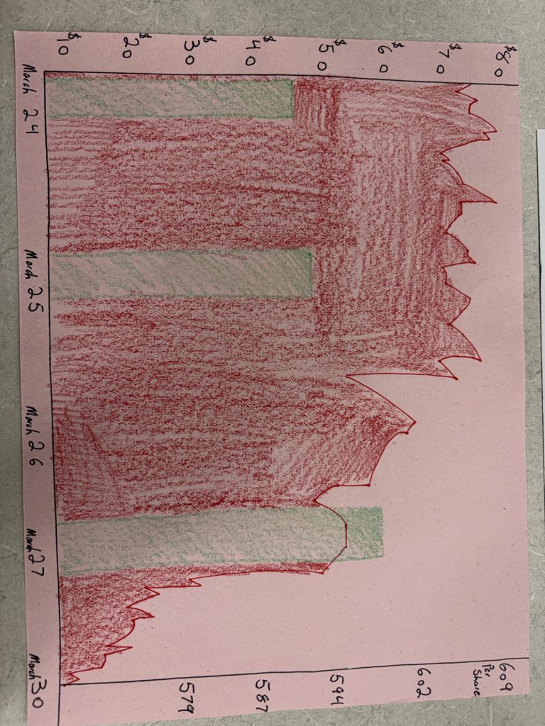
The image I created represents the amount I’ve paid for a tank of gas and the cost of a share of the SMP 500. Their contrast represents the current economic state of the country and the world.